Paris is Magic City, get the most of it !!!
This app takes you where other navigation Apps can't !
This is the "must have" tool to discover the city.
Always know where you are, and where you are going.
• Want to know in which direction to go and how far you are from your destination?
• Want to find your car, return to your starting point?
• What's the name of this Island in front of you ? Where is the volcano ? Where is Montserrat ?
Find the beach, the track, the peak around or far from you. Store its position.
Magic, the map IS a compass and orients itself automatically.
Zoom, Unzoom the map, find your exact position in your district, your city, or the whole region.
Doesn't require any internet nor Wifi connection.
Remember to calibrate the compass for the iPhone every time you start the app. Stay away from electromagnetic interferences. See instructions for details.
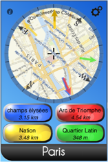
Instructions Main screen The map also displays 4 arrows, each arrow shows you the target direction. If you want to edit a target, simply push the corresponding button.
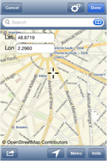
Target screen 6/ Metro Stations: press 7/ Velib Stations: Press When you select OK at the top-right of this screen, the selected position will be selected as a target. You will need to give it a name. Saving a position Miscelaneous |
COMPASS CALIBRATION
Please visit http://support.apple.com/kb/TS2767 for more informations about compass accuracy. |
CONTACT |
CREDITS Conception & Programming Photo Credits Tests Translation Appi-rater code MKStorekit code OpenStreetMap data Redistribution and use in source and binary forms, with or without modification, are permitted provided that the following conditions are met: * Redistributions of source code must retain the above copyright notice, this list of conditions and the following disclaimer. THIS SOFTWARE IS PROVIDED BY THE COPYRIGHT HOLDERS AND CONTRIBUTORS "AS IS" AND ANY EXPRESS OR IMPLIED WARRANTIES, INCLUDING, BUT NOT LIMITED TO, THE IMPLIED WARRANTIES OF MERCHANTABILITY AND FITNESS FOR A PARTICULAR PURPOSE ARE DISCLAIMED. IN NO EVENT SHALL THE COPYRIGHT OWNER OR CONTRIBUTORS BE LIABLE FOR ANY DIRECT, INDIRECT, INCIDENTAL, SPECIAL, EXEMPLARY, OR CONSEQUENTIAL DAMAGES (INCLUDING, BUT NOT LIMITED TO, PROCUREMENT OF SUBSTITUTE GOODS OR SERVICES; LOSS OF USE, DATA, OR PROFITS; OR BUSINESS INTERRUPTION) HOWEVER CAUSED AND ON ANY THEORY OF LIABILITY, WHETHER IN CONTRACT, STRICT LIABILITY, OR TORT (INCLUDING NEGLIGENCE OR OTHERWISE) ARISING IN ANY WAY OUT OF THE USE OF THIS SOFTWARE, EVEN IF ADVISED OF THE POSSIBILITY OF SUCH DAMAGE.
Route-Me depends on the Proj4 Library. [ http://trac.osgeo.org/proj/wiki/WikiStart ] Proj4 is copyright (c) 2000, Frank Warmerdam Permission is hereby granted, free of charge, to any person obtaining a The above copyright notice and this permission notice shall be included THE SOFTWARE IS PROVIDED "AS IS", WITHOUT WARRANTY OF ANY KIND, EXPRESS ABOUT THIS APP |
 The main screen represents a "compass-map" which is automatically centered on your current position. Its orientation is also automatic. You can zoom-in and zoom-out the map by pinching it like in any other IPhone Applications.
 position.